


Science · Weather · Lesson 4 of 8
Air pressure and fronts
Air presses on us all the time. When air masses meet, their boundaries — fronts — often bring a change in the weather.

You cannot see air pressure, but your ears sometimes feel it on a hill. Fronts are where two kinds of air shake hands — or bump.
Highs, lows, and the way air moves
Air pressure is not the same everywhere. In a high-pressure area, or high, air is sinking and usually spreading outward. Sinking air tends to dry out and clear away clouds, so highs often bring fair weather. In a low-pressure area, or low, air is rising. Rising air cools, and clouds and precipitation often form, so lows are more likely to bring unsettled weather. Wind tries to blow from higher pressure toward lower pressure, but Earth's rotation turns that flow, which is why large weather systems spin — a pattern you will meet again in storms.
Air masses
An air mass is a large body of air with similar temperature and moisture throughout. Air that spends a long time over northern Canada in winter can become a cold, dry air mass. Air that lingers over a warm ocean can become warm and moist. When these huge bodies of air move, they bring their character with them. Much of the weather we feel is the arrival, the passing, or the meeting of air masses.
Fronts: the boundaries between air masses
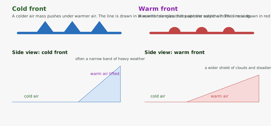
A front is the boundary where two air masses meet. At a cold front, colder air pushes forward and shoves warmer air up, often sharply. Clouds may tower, and a narrow band of heavy rain or thunderstorms can pass, followed by cooler, clearer air. At a warm front, warmer air slides up over a retreating wedge of colder air, usually more gently. A wide shield of clouds may arrive first, then steadier, longer-lasting rain or snow, and then warmer air. A stationary front has stalled. An occluded front forms when a cold front catches up to a warm front. Learning to read front symbols on a map — blue triangles for cold, red half-circles for warm — is like learning a small, useful alphabet.
Check your understanding
Five short questions on this lesson.